October 30, 2012
October 28, 2012
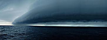
 October 28, 2012– CANADA– After barreling across the Pacific Ocean for hours, a tsunami spawned by an earthquake in Canada struck the Hawaiian Islands. Waves between 3 and 7 feet were expected to lash the islands beginning about 10:28 p.m. Saturday (4:28 a.m. Sunday ET), the Pacific Tsunami Warning Center said. The first waves to hit Honolulu didn’t seem much stronger than usual. But scientists said don’t be fooled by the initial waves, which often aren’t the biggest. “It’s not just one wave, it’s a succession of waves,” Gerard Fryer, senior geophysicist at the center, told reporters. “The following waves, I am sure, will be bigger.” But he noted that the tsunami will not be as significant as the devastating quake and tsunami that killed thousands in Japan in March 2011. Local television showed images of bumper-to-bumper traffic on roads leading from the coast to inner ground. About…
View original post 247 more words
 October 25, 2012– NEW YORK– Much of the U.S. East Coast has a good chance of getting blasted by gale-force winds, flooding, heavy rain and maybe even snow early next week by an unusual hybrid of hurricane and winter storm, federal and private forecasters say. Though still projecting several days ahead of Halloween week, the computer models are spooking meteorologists. Government scientists said Wednesday the storm has a 70 percent chance of smacking the Northeast and mid-Atlantic. Hurricane Sandy in the Caribbean, an early winter storm in the West, and a blast of arctic air from the North are predicted to collide, sloshing and parking over the country’s most populous coastal corridor starting Sunday. The worst of it should peak early Tuesday, but it will stretch into midweek, forecasters say. “It’ll be a rough couple days from Hatteras up to Cape Cod,” said forecaster Jim Cisco of the…
View original post 433 more words
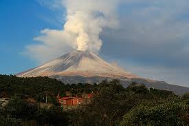 October 27, 2012 – MEXICO – The Popocatepetl volcano unleashed about 70 emissions of low to moderate intensity, several of which were accompanied by ash expulsions reaching a height of 1.5 to 2 kilometers. A night glow was also observed during the night and some of the fumes emitted incandescent fragments near the crater. According to the monitoring system of the National Center for Disaster Prevention (Cenapred), the Volcanic Alert Level remains at Yellow Phase 2. It involves the likelihood that present moderate exhalations, some with ash emissions, sporadic bursts of level low to moderate probability of emission of incandescent fragments, may occur within walking distance of the crater. An incandescent light in the crater of the volcano is also distinctly observable during the night. At the same time, regional civil defense officials placed special emphasis on the following recommendations: continue the safety radius of 12 km, so staying…
View original post 25 more words
 October 27, 2012 – CLIMATE – The steady and dramatic decline in the sea ice cover of the Arctic Ocean over the last three decades has become a focus of media and public attention. At the opposite end of the Earth, however, something more complex is happening. A new NASA study shows that from 1978 to 2010 the total extent of sea ice surrounding Antarctica in the Southern Ocean grew by roughly 6,600 square miles every year, an area larger than the state of Connecticut. And previous research by the same authors indicates that this rate of increase has recently accelerated, up from an average rate of almost 4,300 square miles per year from 1978 to 2006. “There’s been an overall increase in the sea ice cover in the Antarctic, which is the opposite of what is happening in the Arctic,” said lead author Claire Parkinson, a climate scientist with…
View original post 456 more words
